RCRA Facility Investigation/Remedial Investigation
Table of Contents
Risk Assessments
Non-Time Critical Removal Action
Protection of Cultural and Biological Resources
In February 1996, Pacific Gas and Electric Company (PG&E) entered into a voluntary agreement with the California Department of Toxic Substances Control (DTSC)The department within the California Environmental Protection Agency in charge of the regulation of hazardous waste from generation to final disposal. DTSC oversees the investigation and cleanup of hazardous waste sites. to further investigate the nature and extent of contamination at the Topock Project Site (Site) resulting from Topock Compressor Station (Station) operations and to clean up related contamination. This agreement, the Corrective Action Consent AgreementA voluntary agreement between a lead agency and responsible party in which the company commits to investigate the nature and extent of contamination at and surrounding a site governed by RCRA, and to take corrective action., and its 2018 amendment, requires PG&E to follow an investigation and cleanup process governed by a federal law known as the Resource Conservation and Recovery Act (RCRA)A 1976 amendment to the first federal solid waste legislation, the Solid Waste Disposal Act of 1965. In RCRA, Congress established initial directives and guidelines for U.S. EPA to regulate and manage solid waste, including hazardous waste. RCRA established a regulatory system to track hazardous substances from the time of generation to final disposal. The law requires safe and secure procedures to be used in treating, transporting, storing and disposing of hazardous wastes. RCRA was designed to prevent new, uncontrolled hazardous waste sites..
In July 2005, PG&E entered into a voluntary Administrative Consent AgreementA legally binding contract between a lead agency and responsible party that serves to resolve an environmental violation through an administrative settlement agreement rather than through a court action. with the U.S. Department of the Interior (DOI)The United States department charged with conservation and development of natural resources. The U.S. Department of the Interior uses sound science to manage and sustain America’s lands, water, wildlife, and energy resources, honors our nation’s responsibilities to tribal nations, and advocates for America’s island communities.. This Consent Agreement ensures compliance with federal requirements as set forth in Comprehensive Environmental, Response, Compensation, and Liability Act (CERCLA)Commonly known as Superfund, this law created a tax on the chemical and petroleum industries and provided broad federal authority to respond directly to releases or threatened releases of hazardous substances that may endanger public health or the environment. CERCLA established prohibitions and requirements concerning closed and abandoned hazardous waste sites; provided for liability of persons responsible for releases of hazardous waste at these sites; and established a trust fund to provide for cleanup when no responsible party could be identified. The law authorizes two kinds of response actions: Short-term removals, where actions may be taken to address releases or threatened releases requiring prompt response. Long-term remedial response actions, that permanently and significantly reduce the dangers associated with releases or threats of releases of hazardous substances that are serious, but not immediately life threatening..
PG&E agreed to conduct a RCRA Facility Investigation/Remedial Investigation (RFI/RI)An investigation that occurs in the corrective action process following a Facility Assessment under RCRA and/or a Site Inspection under CERCLA. It is an in-depth study designed to gather data needed to determine the nature and extent of contamination at a site. to determine the extent of contamination and potential impacts to human health and the environment, and to gather information to support the evaluation and selection of remedies to address the contamination as necessary. RFI/RI data collection activities started in 1996.
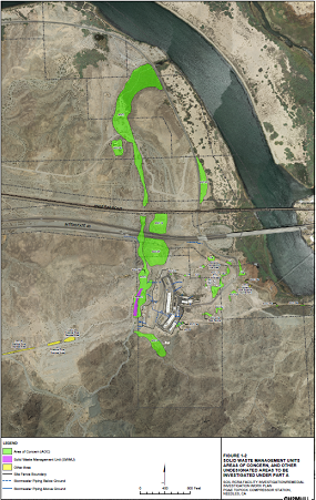
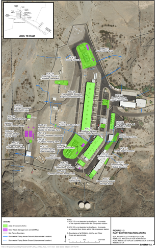
There have been multiple phases of investigation at the Site to collect data to evaluate the nature and extent of soil contamination at the Solid Waste Management Units, Areas of Concern, and Undesignated Areas. There are 15 soil investigation areas located outside the Station fence line (see figure below) and 27 soil investigation areas located inside the Station fence line (see figure below). The perimeter area outside of, but adjacent to, the Station fence line and the storm drain system were also investigated during the soil investigation.
(Click on images above for larger view)
Since some of the property affected by operations at the Station is owned and managed by the federal government, the DOI is overseeing remedial actions pursuant to CERCLA. Therefore, the RFI/RI reports have been prepared to satisfy both RCRA (as managed by DTSC) and CERCLA requirements.
Soil sampling and related Soil Investigation field work was completed between December 2015 and March 2016, January through March 2017, and the latter part of April 2017. That work fulfilled requirements of the Topock Soil Facility Investigation/ Remedial Investigation (RFI/RI) Work Plan and Data Gap Work Plans #1, #2, and #3. Field work included:
- Collection of soil samples at 364 locations.
- Trenching of 15 locations to evaluate possible contamination.
- Collection of sediment and pore water samples from 10 locations at the edge of the Colorado River by the East Ravine.
The field work was conducted in phases and in an iterative process. After each sample collection effort was completed, results were evaluated by DTSC, the U.S. Department of the Interior (DOI), and PG&E to determine data gaps and if additional data collection effort was needed to complete the Soil Investigation and evaluate potential next steps. The agencies and PG&E balanced the data collection necessary with Tribes request to minimize site intrusion by maximizing the use of archived samples and collection of samples from existing locations.
On June 20, 2017, PG&E began the risk evaluation process per the approved Risk Assessment Work Plan and addendum. The risk assessment evaluated potential human health and ecological risks based on soil sampling data. This information will assess risk management decisions on the need for soil remediation. The Soil Risk Assessment report plus errata were approved in May 29, 2020. The report and errata can be downloaded here.
Concurrently, the preparation of the Soil RFI/RI Report (also called the RFI/RI Volume 3 Report) has begun. The Soil RFI/RI Report will present findings and conclusions of the soil investigation field work and the conclusions from the Risk Assessment. The Soil RFI/RI Report is anticipated to be completed in early 2023.
Due to timing differences in the investigation and reporting of the resulting data, the Final RFI/RI report has been divided into three separate volumes:
- Volume 1 - Site Background and History
- Volume 2 – Hydrogeological Characterization and Results of Groundwater and Surface Water Investigation
- Volume 3 - Soil Characterization Results
Volumes 1 and 2 are discussed in the Groundwater Cleanup – RCRA Facility Investigation/Remedial Investigation pages.
The Volume 3 Report will include the final soil characterization results (including a soil risk assessmentA study prepared to assess health and environmental risks due to potential exposure to hazardous substances.) to complete the RFI/RI requirements for the Site. The first phase of soil investigation in areas outside of the Station was completed in 2008. Soil data have been reviewed, and data gaps have been identified. A Draft Soil RFI/RI Work Plan, which describes the additional data needed to address the identified data gaps at the Site, was prepared and submitted on May 6, 2011. A revised Soil Work Plan was submitted on January 14, 2013, which proposed additional soil investigation for all areas of the Site. Pursuant to the California Environmental Quality Act (CEQA), DTSC evaluated the environmental impacts associated with the soil investigation in the Final Soil EIR. DTSC filed a determination and certified the Final Soil EIR on August 24, 2015 along with the approval of the Final Work Plan. DOI also approved the Soil RFI/RI Work Plan on August 24, 2015. PG&E began the soil field investigation on October 29, 2015 and completed it in April 2017. The draft Soil RFI/RI Report was submitted on December 2019 and it was revised based on agencies comments. PG&E submitted a revised Soil RFI/RI Volume 3 report on May 31, 2021. All comments received were responded to and sent for review on December 20, 2021. Subsequently, four meetings were held in February 2022 to resolve a subset of the responses. Revised text of key report sections was prepared and sent for review in September 2022. Revision of the report based on comments received is complete, and the final RFI/RI Volume 3 Report was submitted to DTSC and DOI on October 2, 2023. DTSC accepted the final report on June 10, 2024. DOI provided concurrence with DTSC’s acceptance on June 25, 2024.
Risk Assessments
To guide decisions based on potential risks to human and ecological health at the Site, PG&E prepared a comprehensive Human Health and Ecological Risk Assessment Work Plans for soil. The Risk Assessment Work Plan was submitted on August 25, 2008. An addendum was submitted on February 4, 2009. On September 19-20, 2013, DTSC, DOI, PG&E, and Tribal Nations met to discuss amendments to the Soil Risk Assessment Work Plan. A Risk Assessment Work Plan Addendum II was submitted on May 7, 2014, and contains updated information relevant to soil risk assessment activities and evaluation based on comments received by Tribal Nations, agencies, and stakeholders. The Final Human Health and Ecological Risk Assessment Work Plan Addendum 2 was submitted on June 29, 2015. DTSC conditionally approved the Soil Risk Assessment Addendum II on August 31, 2015 (clarified on September 15, 2015) and DOI conditionally approved the Addendum 2 on September 8, 2015. Upon completion of the soil investigation field work and discussion of soil data, DTSC and DOI concurred with PG&E to begin the soil risk evaluation process on June 20, 2017. The Soil Risk Assessment report was submitted to agencies on October 18, 2019, and an errata was submitted on February 19, 2020. The Soil Risk Assessment Report plus errata were approved on May 29, 2020.
Currently no pilot studies are planned for soil cleanup and remediation. If soil cleanup is determined to be necessary, PG&E may conduct pilot studies and tests to evaluate the various remedial technologies for the soil cleanup in the future.
Non-Time Critical Removal Action
Areas were identified through the soil investigation and the Human Health and Ecological Risk Assessment that contamination has either impacted or may potentially impact federal lands. As a result, DOI contemplated a potential removal action for the protection of the wildlife refuge. On October 30, 2018, DOI directed PG&E to prepare a draft Soil Engineering Evaluation/Cost Analysis (EE/CA). The purpose of an EE/CA is to evaluate the need for a non-time critical removal action (NTCRA) on federal lands or at locations where contamination has the potential to migrate to federal land. The draft EE/CA, which was submitted on May 29, 2020, considered a range of options including no action, separation of soil by size with soil washing, or complete removal and disposal of the contaminated soil. The public comment period for the draft EE/CA was held from June 3, 2020 to August 5, 2020. DOI issued responses to comments on April 23, 202 and directed PG&E to revise the draft EE/CA. The final EE/CA can be found here. DOI prepared and approved a decision document called an Action Memorandum for the NTCRA on October 12, 2021. The Action Memorandum, along with a Responsiveness Summary and the Final EE/CA, can be found here.
Protection of Cultural and Biological Resources
The Site is part of a larger geographic area that is considered sacred by some Native American Tribal Nations. In the 2011 Final EIR, DTSC concluded that the 779.2‐acre Site “appears to qualify as a historic resource under CEQA as an area that is significant in the social and cultural annals of California,” and the U.S. Bureau of Land Management (BLM) also has determined that a traditional cultural property or property of traditional religious and cultural significance that is eligible for listing in the National Register of Historic Places exists in the area of the Site, within the current Area of Potential Effect, consisting of 1,600 acres of surface area and a section of the Colorado River. Among the larger and better known cultural resources on the Site is an expansive desert geoglyph or intaglio, known as the Topock Maze.
Prominent historic‐era features in the landscape also overlie the groundwaterWater beneath the Earth’s surface that flows through soil and rock openings (aquifers). plumeA body of contaminated groundwater. The movement of a groundwater plume can be influenced by such factors as local groundwater flow patterns, the character of the aquifer in which the groundwater is contained, and the density of contaminants., including segments of historic U.S. Route 66, the National Trails Highway (also known as the National Old Trails Highway), and the right-of-way of the BNSF Railway. A broad spectrum of archaeological resources is also present within the Site and on adjacent lands. Properties on and near the Site that are eligible for or listed in the National Register of Historic Places include Native American cultural resources and elements of the historic “built environment.”
For these reasons, all remedial activities at the Station are planned in such a way as to minimize impact to this area. Impacts to cultural and archaeological/historical and biological resources will be minimized by implementing the mitigation measures required by the Mitigation Monitoring and Reporting Program (MMRP) adopted by DTSC in 2011 as part of the certified EIR, was updated in the 2018 certified Final Subsequent EIR, as well as measures under the Programmatic Agreement, the Cultural and Historic Properties Management Plan, and in consultation with Tribal Nations throughout the investigative activities.
A large portion of the Site and surrounding area is the Havasu National Wildlife Refuge. Portions of the Site are also located in a Riparian and Cultural Area of Critical Environmental Concern and the Topock‐Needles Special Cultural Resource Management Area, designated under the BLM Resources Management Plan. Impacts to biological resources will also be minimized by implementing the mitigation measures required by the MMRPS, Programmatic Biological Assessment (PBA), the Avoidance and Minimization Measures required by the California Department of Fish and Wildlife, as well as compliance with Applicable or Relevant and Appropriate Requirements included in the DOI's Record of Decision.
PG&E has also worked closely with biologists to ensure appropriate measures are taken to protect sensitive desert habitat during all aspects of Project implementation. A PBA was completed in January 2007 to cover remediation and investigation projects at the Site up to the final groundwater remedy. On December 27, 2012, the 2007 PBA was modified and extended for 5 years (until 2017). On April 12, 2018, the 2007 PBA was modified and extended an additional 10 years (until 2027). Authorization for the extension and modification of the 2007 PBA can be found here. A PBA was submitted April 28, 2014, and covers activities related to implementation of the groundwater remedy. The 2007 and the 2014 PBA can be found here. For habitat improvement, mesquite trees were planted on the Havasu National Wildlife Refuge and a drip irrigation system was installed to ensure their survival.
Surveys and monitoring to ensure biological and cultural resource protection will continue to be a priority as investigative and remedial activities progress at the Site. A listing of recent surveys and monitoring activities is provided here.