Activities at a Glance
Groundwater Remedy
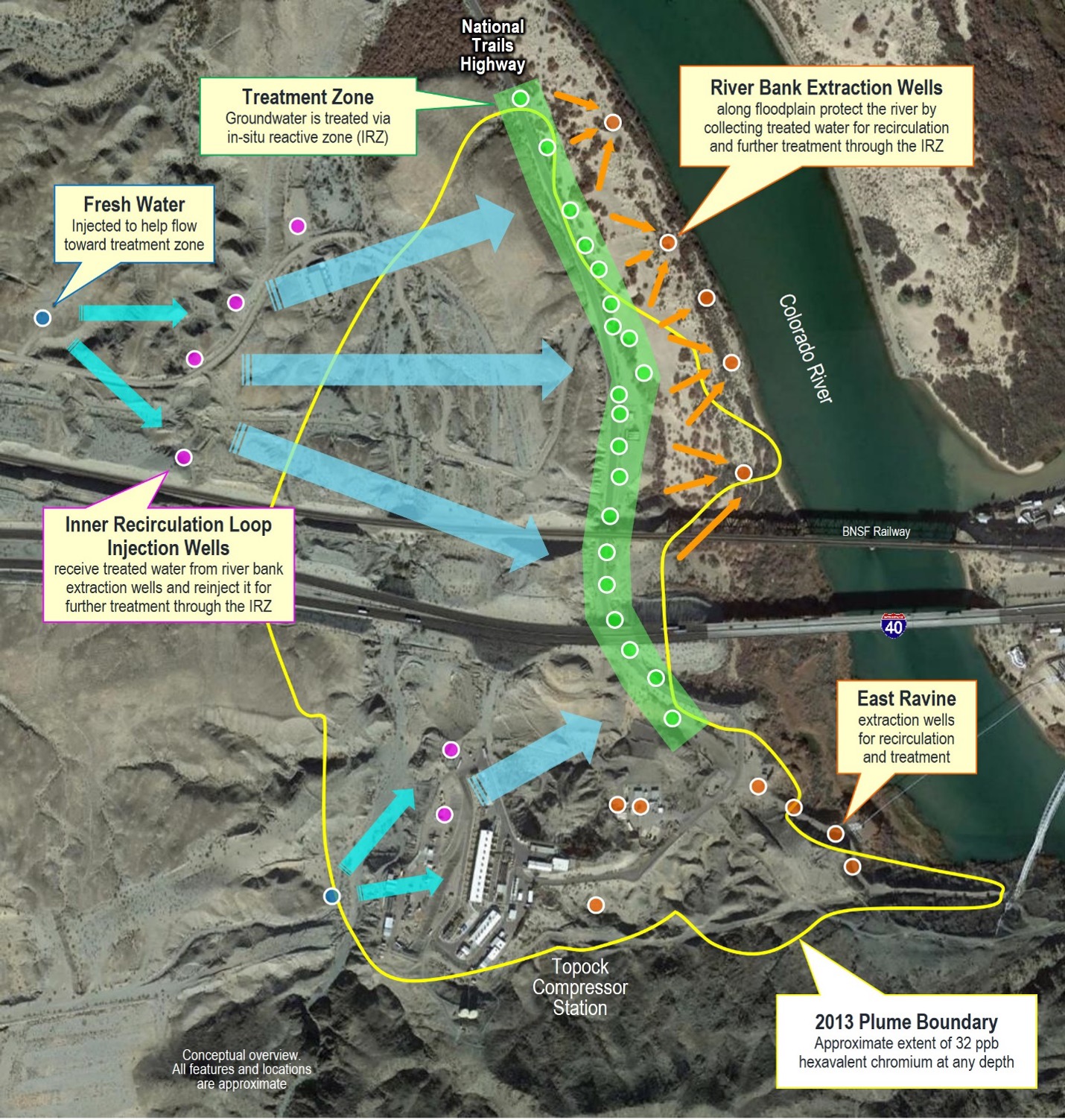
Simplified for illustration purposes, the map below shows a bird’s eye view of the groundwater remedy and its major components. Those components include the in-situ reactive zone (IRZ) along National Trails Highway; the extraction wells along the river and in the East Ravine; the upland recirculation injection wells for water that is extracted, amended with carbon, and reinjected at the IRZ; and the fresh water injection wells that will help push the plume toward and through the IRZ. Not shown on this map is some of the other supporting infrastructure and the extensive network of monitoring wells that are used to constantly monitor the plume and effectiveness of the remedy.
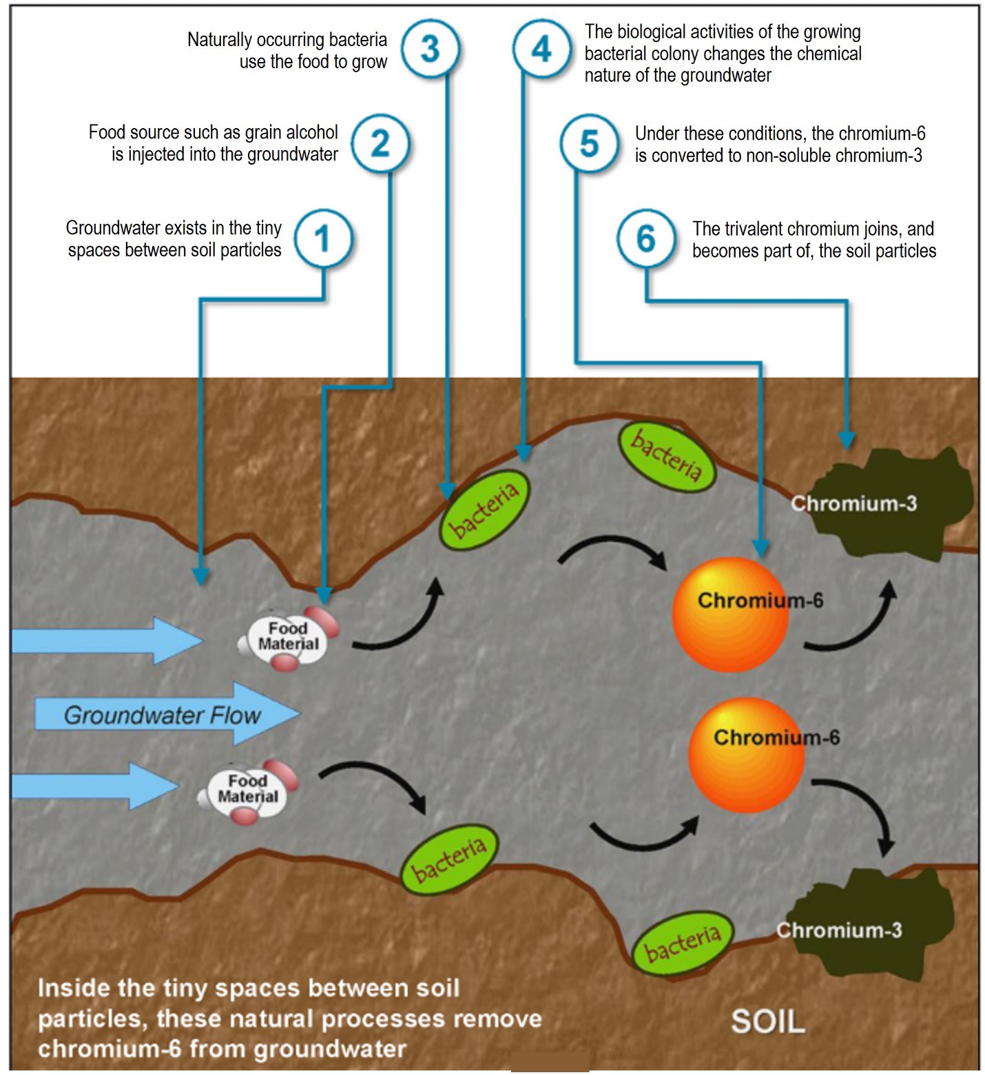
In-situ or “in place” treatment is an effective method to clean-up environmental contamination without first removing the contaminant out of its existing location. PG&E will use this in-situ method to safely remove the hexavalent chromium from groundwater while maintaining the water as a regional resource. The illustration below zooms into the microscopic space between soil particles to show what happens during the approved in-situ treatment. The selected remedy involves both a biological and chemical process which begins by injecting a food source, or “reagent” into the affected groundwater to stimulate the growth of naturally occurring bacteria within the soil. The food source currently being used at the site is an alcohol, but could also be provided as sugars or oils. The biological activity of the bacteria creates conditions that convert hexavalent chromium to trivalent chromium, a naturally abundant substance. Once converted, trivalent chromium leaves the groundwater and becomes part of the surrounding soil. Although the converted trivalent chromium will not likely revert back to hexavalent chromium, the changes in subsurface conditions that convert the hexavalent chromium to trivalent are temporary and will return to baseline conditions after the injections of reagent end.
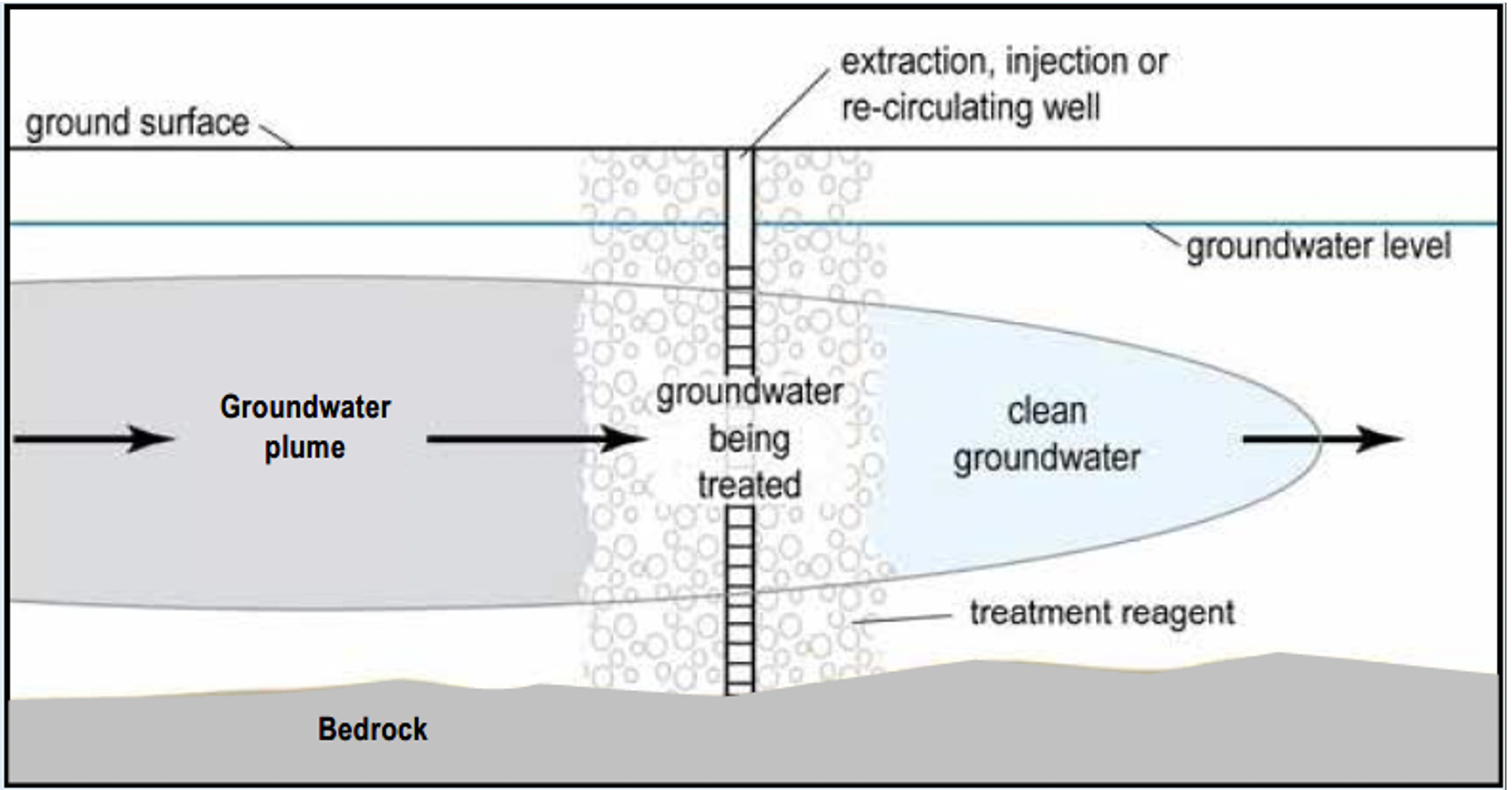
For the freshwater flushing component of the groundwater remedy, injection wells located around the hexavalent chromium groundwater plume will pump freshwater into the ground. The freshwater will push the contaminated groundwater through the IRZ for treatment. Below is an illustration of how the groundwater plume is pushed through the IRZ. Fresh water for flushing will be supplied from wells in Arizona.
Soil Investigation and Cleanup Update
The soil Investigation was completed in the second quarter of 2017. Soil sampling and related Soil Investigation field work was conducted between December 2015 and March 2016, January through March 2017, and the latter part of April 2017. That work fulfilled the requirements of the Topock Soil Facility Investigation/ Remedial Investigation (RFI/RI) Work Plan and Data Gap Work Plans #1, #2, and #3. Field Work included:
- Collection of soil samples at 364 locations.
- Trenching of 15 locations to evaluate possible contamination.
- Collection of sediment and pore water samples from 10 locations at the edge of the Colorado River by the East Ravine.
After sample collection was completed, results were evaluated by the Department of Toxic Substances Control (DTSC), the U.S. Department of the Interior (DOI), and PG&E to determine if additional data collection is needed to complete the Soil Investigation and evaluate potential next steps. The agencies and PG&E balanced the data collection necessary with Tribes’ request to minimize site intrusion by maximizing the use of archived samples and collection of samples from previously disturbed locations.
The Soil RFI/RI field work was completed in April 2017. Findings and conclusions of the soil investigation field work and the conclusions from the Soil Risk Assessment (see below) are presented in the Soil RFI/RI Report (also called the RFI/RI Volume 3 Report). PG&E submitted a revised Soil RFI/RI Volume 3 report on May 31, 2021 for review and comment. All comments received were responded to and sent for review on December 20, 2021. Subsequently, four meetings were held in February 2022 to resolve a subset of the responses. Revised text of key report sections was prepared and sent for review in September 2022. Revision of the report based on comments received is complete, and the final RFI/RI Volume 3 Report was submitted to DTSC and DOI on October 2, 2023. DTSC accepted the final report on June 10, 2024. DOI provided concurrence with DTSC’s acceptance on June 25, 2024. This report, found here, will assist decision-making regarding the need for soil remediation.
Following the final RFI/RI Report, a Corrective Measure Study/Feasibility Study (CMS/FS) for soil will be prepared to evaluate and consider any actions that may be needed at the Site.
On October 12, 2021, DOI selected a removal action of excavation of contaminated soil and debris at target action areas within the Topock Site. The removal action consists of mechanical separation/size separation of rocks, debris, and soil; and disposal of the contaminated soil and debris in approved and permitted landfills. DOI’s decision is documented in an Action Memorandum which can be found here.
In the Action Memorandum, DOI directed PG&E to prepare a work plan to conduct the Non-Time Critical Removal Action (NTCRA). A draft plan was submitted in October 2021 for DOI’s review. DOI solicited comments on the draft work plan from DTSC, Tribes, and stakeholders. Meetings were held in April and May 2022 to discuss the responses. A final Soil NTCRA Work plan was submitted on June 17, 2022. The final Work Plan can be found here. The Response to Comments Table can be downloaded here. DOI approved the final Soil NTCRA Work Plan on June 27, 2022.
PG&E commenced the NTCRA soil removal action on July 25, 2022. Work was completed in February 2024 and approximately 34,706 cubic yards of contaminated soil/debris was removed.
Pursuant to the final Soil NTCRA Work Plan, PG&E is preparing a Completion Report for submittal to DOI following completion of the field implementation.
Soil Risk Assessment Update
A Final Risk Assessment Work Plan Addendum II was submitted June 29, 2015 and contains updated information relevant to soil risk assessment activities and evaluation based on comments received by Tribal Nations, agencies, and stakeholders. DTSC approved the Soil Risk Assessment Work Plan (submitted August 25, 2008) and the Risk Assessment Work Plan Addendum (submitted February 4, 2009) together referred to as the Final Risk Assessment Work Plan (RAWP). DTSC conditionally approved the Soil Risk Assessment Addendum II on August 31, 2015 (clarified on September 15, 2015) and DOI conditionally approved the Soil Risk Assessment Addendum II on September 8, 2015. On June 20, 2017, DTSC and DOI determined that the Soil RFI/RI field work was completed and concurred with PG&E to move forward with the risk evaluation process according to the approved Risk Assessment Work Plan and Addendum.
The final Soil Risk Assessment Report was published in October 2019 and the errata was published in February 2020. They were approved in May 2020 and the approval can be found here. The report concludes that there is minimal unacceptable risk to human health and wildlife exposed to soil at the site. However, it also identifies nine small and isolated areas that pose unacceptable risk for campers, hikers, Off-Highway Vehicle riders, and desert shrews if exposed to contaminated soil. These nine areas are located around the PG&E Topock Compressor Station (some on PG&E owned land and some on federal lands) and will be evaluated for corrective action.
Corrective action began in these areas as described in the workplan for a NTCRA, approved by DOI on June 27, 2022. PG&E commenced the EE/CA soil removal action on July 25, 2022.
Interim Measures
Since 2005, the Interim Measures' goal of maintaining contaminated groundwater flow away from the Colorado River had been met, as reported in the Quarterly Performance Monitoring/Groundwater Monitoring Reports. However, the Interim Measure 3 (IM-3) groundwater extraction and treatment system is incompatible with the final remedy in-situ treatment process, and IM-3 ceased operations just prior to the startup of the groundwater remedy on December 22, 2021. The IM-3 system is currently in layup mode to eventually be decommissioned after the remedy demonstrates that it is operating as designed. IM-3 had operated continuously and successfully since 2005. During operation, the IM-3 groundwater extraction and treatment system has extracted and treated over 1,000,000,000 gallons of water and removed 8,470 pounds of chromium from August 1, 2005 through December 21, 2021.
DTSC's Mitigation Measures
Mitigation measures were adopted as part of the January 31, 2011 certified final groundwater EIR and 2013 addendum groundwater EIR. Additional or revised mitigation measures were adopted from the certified Subsequent EIR for the groundwater remedy in April 2018. These mitigation measures were adopted to reduce potential impacts to the environment during the groundwater cleanup. Implementation of these mitigation measures is ongoing.
Mitigation measures were also adopted as part of the August 24, 2015 certified Soil Investigation EIR. Although they are similar to groundwater measures, they remain in effect for soil investigation activities such as potential bench scale tests, pilot studies, and geotechnical evaluations to support, inform, and enable, if necessary, the evaluation and selection of corrective measures in a future Soil Corrective Measures Study/Feasibility Study (CMS/FS).
DOI’s Applicable, Relevant, and Appropriate Requirements (ARARs) and Other Advisories, Criteria, and Guidance To Be Considered (TBCs)
ARARs Applicable, Relevant, and Appropriate Requirements (ARAR) Federal or state laws, regulations, standards, criteria, or requirements that would apply to the cleanup of hazardous substances at a particular site.and TBCs were identified in the Groundwater Record of Decision issued in December 2010. Implementation of the Groundwater ARARs is ongoing. Similarly, ARARs and TBCs were identified in the Soil NTCRA Work Plan approved by DOI on June 27, 2022. Implementation of the Soil NTCRA ARARs and TBCs is ongoing.
ARARs and TBCs are identified by DOI with inputs from State and Local agencies. ARARs are promulgated requirements or standards that a remedial action such as the groundwater remedy or removal action such as the Soil NTCRA must attain to assure an implemented remedial or removal action is protective of human health and the environment. TBCs are advisories, criteria, and guidance that can be used to inform the selection of a remedial or removal action.
Monitoring and Survey Activities
The following monitoring and survey activities were conducted or are planned:
- With the start-up of the Phase 1 groundwater remedy and shut down of the IM No. 3 system in December 2021, the IM performance monitoring and the site-wide groundwater and surface water monitoring programs have transitioned to a remedy monitoring program. Results are reported in the quarterly progress reports.
- An archeological/cultural survey of areas within the SEIR Project Area that have not been formally surveyed in the past 5 years began on March 15, 2021 and was completed on April 30, 2021.
- A bat habitat assessment survey was conducted from April 8-12, 2021 and June 16-18, 2021. The survey shows that the roosting bat colonies were not impacted by the ongoing groundwater remedy construction activities.
- Southwestern willow flycatcher protocol surveys were conducted on May 17-19, 2021, June 7-9, 2021, June 14-16, 2021, June 28-30, 2021 and July 12-14, 2021. Three southwestern willow flycatchers were detected during the survey and the next survey is scheduled for 2024.
- Biological, archeological, cultural, and paleontological monitoring is conducted as part of the construction activities.
- The Annual Site Conditions Assessment occurred on December 8-10, 2021 in accordance with the mitigation measures adopted by DTSC in the 2011 Groundwater Remedy Final EIR and the 2018 Subsequent Final EIR.